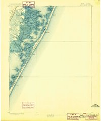
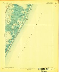
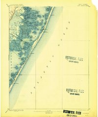
1893 Map of Long Beach
USGS Topo · Published 1899About this map
The Long Beach Railroad runs the length of the narrow barrier island in the 1880s, providing a vital link for early seaside development. This coastal survey shows the barrier landscape before modern intensive urbanization, where small clusters like Beach Haven and Harvey Cedars stand as primary settlements amidst an intricate network of marshes and bays. The shoreline is punctuated by multiple life-saving outposts, including L.S. Station Ships Bottom and L.S. Station Long Beach, reflecting the maritime hazards of the era.
Find a feature on this map
40 named features on this map. Tap any name to fly to it.
Don’t see what you’re looking for? This feature index may not catch every label — zoom into the map to look around manually.
Map Details
Editions of this 1893 Long Beach Map
4 editions found
Other maps of this area

1884 · Whitings
USGS Topo · 1:62,500

1887 · Atlantic City
USGS Topo · 1:62,500

1888 · Barnegat
USGS Topo · 1:62,500

1888 · Little Egg Harbor
USGS Topo · 1:62,500

1888 · Long Beach
USGS Topo · 1:62,500

1888 · Whitings
USGS Topo · 1:62,500

1893 · Little Egg Harbor
USGS Topo · 1:62,500

1893 · Long Beach
USGS Topo · 1:62,500

1893 · Barnegat
USGS Topo · 1:62,500

1894 · Atlantic City
USGS Topo · 1:62,500
Featured Places
- Stafford Township, NJ
- Barnegat Township, NJ
- Long Beach Township, NJ
- Eagleswood Township, NJ
- Surf City, NJ