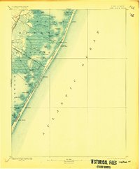
1893 Map of Long Beach
USGS Topo · Published 1907About this map
Beach Haven and the thin ribbons of the Philadelphia and Beach Haven RR anchor this coastal landscape during the late nineteenth century. The map illustrates a maritime environment defined by barrier islands and extensive salt marshes, where the life-saving service maintained a critical presence through stations like L.S. Station Ship Bottom and L.S. Station Long Beach. To the west, the waters of Barnegat Bay and Little Egg Harbor are dotted with numerous named sedges and islands, including Sloop Sedge and Marsh Elder Islands. This survey captures the region just as the railroad was facilitating the early growth of beach settlements like Harvey Cedars. The intricate network of waterways, such as Gunning River and Mill Creek, highlights the complex interface between the mainland and the shifting sands of the Jersey Shore before modern coastal development transformed the coastline.
Find a feature on this map
42 named features on this map. Tap any name to fly to it.
Don’t see what you’re looking for? This feature index may not catch every label — zoom into the map to look around manually.
Map Details
Editions of this 1893 Long Beach Map
4 editions found
Other maps of this area

1884 · Whitings
USGS Topo · 1:62,500

1887 · Atlantic City
USGS Topo · 1:62,500

1888 · Barnegat
USGS Topo · 1:62,500

1888 · Little Egg Harbor
USGS Topo · 1:62,500

1888 · Long Beach
USGS Topo · 1:62,500

1888 · Whitings
USGS Topo · 1:62,500

1893 · Little Egg Harbor
USGS Topo · 1:62,500

1893 · Long Beach
USGS Topo · 1:62,500

1893 · Barnegat
USGS Topo · 1:62,500

1894 · Atlantic City
USGS Topo · 1:62,500
Featured Places
- Stafford Township, NJ
- Barnegat Township, NJ
- Long Beach Township, NJ
- Eagleswood Township, NJ
- Surf City, NJ