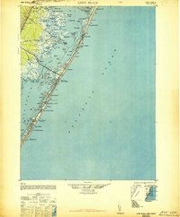
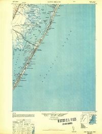
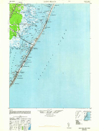
1948 Map of Long Beach
USGS Topo · Published 1948About this map
Long Beach barrier island is documented here just after the war, showing a string of coastal settlements connected by the Main Road. The landscape is dominated by the narrow strip of dunes and beaches separating the Atlantic Ocean from the intricate wetlands of Manahawkin Bay. Notable infrastructure includes the American Telephone and Telegraph Co Transatlantic Receiver and the Harvey Cedars CG 115 station, reflecting the island's strategic maritime and communications importance during this era.
Find a feature on this map
79 named features on this map. Tap any name to fly to it.
Don’t see what you’re looking for? This feature index may not catch every label — zoom into the map to look around manually.
Map Details
Editions of this 1948 Long Beach Map
3 editions found
Other maps of this area

1884 · Whitings
USGS Topo · 1:62,500

1887 · Atlantic City
USGS Topo · 1:62,500

1888 · Barnegat
USGS Topo · 1:62,500

1888 · Little Egg Harbor
USGS Topo · 1:62,500

1888 · Long Beach
USGS Topo · 1:62,500

1888 · Whitings
USGS Topo · 1:62,500

1893 · Little Egg Harbor
USGS Topo · 1:62,500

1893 · Long Beach
USGS Topo · 1:62,500

1893 · Barnegat
USGS Topo · 1:62,500

1894 · Atlantic City
USGS Topo · 1:62,500
Featured Places
- Stafford Township, NJ
- Barnegat Township, NJ
- Long Beach Township, NJ
- Eagleswood Township, NJ
- Surf City, NJ