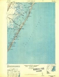
1948 Map of Long Beach
USGS Topo · Published 1948About this map
Barnegat Bay separates the mainland of Ocean County from the slender barrier island of Long Beach, creating a landscape defined by tidal creeks and complex sedges. The mainland side, near Barnegat and Hilliard, features an intricate network of waterways including the Gunning River and Big Flat Creek, alongside the Public Shooting Grounds. An interesting industrial landmark of the early Cold War era is the American Telephone and Telegraph Co Transatlantic Receiver located in the marshes of the Harvey Sedges. On the barrier island, a string of coastal communities including Harvey Cedars, Surf City, and Ship Bottom - Beach Arlington are connected by a developing road network and the Jersey Central Lines railroad. The map illustrates the specialized infrastructure of the shore, from the Long Beach Township Hall to the numerous small landings and ponds that supported local maritime life before the period of heavy modern development.
Find a feature on this map
74 named features on this map. Tap any name to fly to it.
Don’t see what you’re looking for? This feature index may not catch every label — zoom into the map to look around manually.
Map Details
Editions of this 1948 Long Beach Map
3 editions found
Other maps of this area

1884 · Whitings
USGS Topo · 1:62,500

1887 · Atlantic City
USGS Topo · 1:62,500

1888 · Barnegat
USGS Topo · 1:62,500

1888 · Little Egg Harbor
USGS Topo · 1:62,500

1888 · Long Beach
USGS Topo · 1:62,500

1888 · Whitings
USGS Topo · 1:62,500

1893 · Little Egg Harbor
USGS Topo · 1:62,500

1893 · Long Beach
USGS Topo · 1:62,500

1893 · Barnegat
USGS Topo · 1:62,500

1894 · Atlantic City
USGS Topo · 1:62,500
Featured Places
- Stafford Township, NJ
- Barnegat Township, NJ
- Long Beach Township, NJ
- Eagleswood Township, NJ
- Surf City, NJ