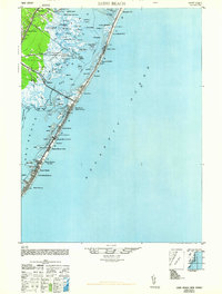
1948 Map of Long Beach
USGS Topo · Published 1963About this map
Long Beach island stretches across this mid-century survey, a slender barrier of sand between the Atlantic Ocean and the intricate wetlands of Barnegat Bay. The map documents a sequence of early shore communities connected by the long spine of the coastal road, from Barnegat City at the northern tip down through Harvey Cedars and Surf City to the more densely settled Beach Haven. A notable technical landmark of the era is the American Telephone and Telegraph Co Transatlantic Receiver located inland near Manahawkin Road. The tidal landscape is meticulously detailed, showing the complex network of sedges and islands like Carvel I and Marsh Elder I. On the mainland, the Public Shooting Grounds and small settlements like Beach View reflect the area's dual character as both a residential retreat and a center for coastal sporting life.
Find a feature on this map
75 named features on this map. Tap any name to fly to it.
Don’t see what you’re looking for? This feature index may not catch every label — zoom into the map to look around manually.
Map Details
Editions of this 1948 Long Beach Map
3 editions found
Other maps of this area

1884 · Whitings
USGS Topo · 1:62,500

1887 · Atlantic City
USGS Topo · 1:62,500

1888 · Barnegat
USGS Topo · 1:62,500

1888 · Little Egg Harbor
USGS Topo · 1:62,500

1888 · Long Beach
USGS Topo · 1:62,500

1888 · Whitings
USGS Topo · 1:62,500

1893 · Little Egg Harbor
USGS Topo · 1:62,500

1893 · Long Beach
USGS Topo · 1:62,500

1893 · Barnegat
USGS Topo · 1:62,500

1894 · Atlantic City
USGS Topo · 1:62,500
Featured Places
- Stafford Township, NJ
- Barnegat Township, NJ
- Long Beach Township, NJ
- Eagleswood Township, NJ
- Surf City, NJ