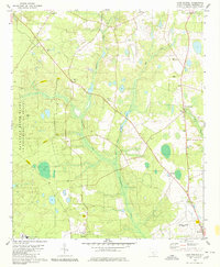
1979 Map of Long Branch
USGS Topo · Published 1980About this map
The Savannah River Plant U S Department of Energy defines the western portion of this Barnwell County landscape, with its perimeter marked by gates and restricted zones. This nuclear industrial presence contrasts with the traditional rural character of the eastern half, where small settlements like Elko and Snelling are connected by a network of local roads and pipelines. The area is heavily influenced by the headwaters of the Salkehatchie River, which is fed by numerous tributaries including Rosemary Creek, Buck Creek, and Long Branch. Genealogists and local historians can find a wealth of burial grounds and rural congregations, from the Great Cypress Cem and Hair Cem to the New Jerusalem Ch and Springfield Ch. South of the energy plant, the Barnwell County Airport sits just north of the city of Barnwell, while small crossroads like Seven Pines provide further evidence of the region's historic settlement patterns.
Find a feature on this map
28 named features on this map. Tap any name to fly to it.
Don’t see what you’re looking for? This feature index may not catch every label — zoom into the map to look around manually.
Map Details
Editions of this 1979 Long Branch Map
2 editions found
Other maps of this area

1919 · Allendale
USGS Topo · 1:62,500

1920 · Ellenton
USGS Topo · 1:48,000

1920 · Talatha
USGS Topo · 1:48,000

1921 · Talatha
USGS Topo · 1:62,500

1921 · Ellenton
USGS Topo · 1:62,500

1923 · Williston
USGS Topo · 1:48,000

1927 · Williston
USGS Topo · 1:62,500

1943 · Allendale
USGS Topo · 1:62,500

1943 · Augusta East
USGS Topo · 1:125,000

1943 · Williston
USGS Topo · 1:62,500