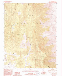
1987 Map of Long Canyon
USGS Topo · Published 1994About this map
Sequoia National Forest and the South Sierra Wilderness dominate this high-elevation landscape along the border of Tulare and Inyo Counties. The map documents the headwaters and drainage patterns of the South Fork Kern River, which winds through the western portion of the sheet near Clover Meadow. This is a terrain of dramatic vertical relief, defined by the towering presence of Ball Mountain and a series of deep cuts including Long Canyon, Johnson Canyon, and Tunawee Canyon.
Find a feature on this map
23 named features on this map. Tap any name to fly to it.
Don’t see what you’re looking for? This feature index may not catch every label — zoom into the map to look around manually.
Map Details
Editions of this 1987 Long Canyon Map
2 editions found
Other maps of this area

1905 · Olancha
USGS Topo · 1:125,000

1906 · Kernville
USGS Topo · 1:125,000

1907 · Olancha
USGS Topo · 1:125,000

1908 · Kernville
USGS Topo · 1:125,000

1908 · Ballarat
USGS Topo · 1:250,000

1913 · Ballarat
USGS Topo · 1:250,000

1915 · Searles Lake
USGS Topo · 1:250,000

1947 · Trona
USGS Topo · 1:250,000

1948 · Trona
USGS Topo · 1:250,000

1948 · Death Valley
USGS Topo · 1:250,000