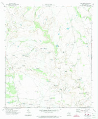
1970 Map of Long Draw
USGS Topo · Published 1974About this map
The Colorado River meanders across this West Texas landscape, cutting through a region defined by cattle ranching and intensive petroleum extraction. The presence of the Muleshoe Ranch and a designated Landing Strip suggests the scale of landholdings in Borden County during this period. The terrain is deeply carved by drainage systems like Tobacco Creek, Long Draw, and Grape Creek, which are dotted with numerous man-made water catchments such as Railroad Tank and Johnson Tank.
Find a feature on this map
45 named features on this map. Tap any name to fly to it.
Don’t see what you’re looking for? This feature index may not catch every label — zoom into the map to look around manually.
Map Details
Editions of this 1970 Long Draw Map
This is the sole edition of this map. No revisions or reprints were ever made.
Other maps of this area

1954 · Big Spring
USGS Topo · 1:250,000

1958 · Big Spring
USGS Topo · 1:250,000

1969 · Gail
USGS Topo · 1:24,000

1969 · Indian Canyon
USGS Topo · 1:24,000

1969 · Holloway Canyon
USGS Topo · 1:24,000

1970 · Vealmoor
USGS Topo · 1:24,000

1970 · Mushaway Peak
USGS Topo · 1:24,000

1970 · Ackerly
USGS Topo · 1:24,000
1970 · Gunsight Draw
USGS Topo · 1:24,000

1970 · Sand Creek
USGS Topo · 1:24,000