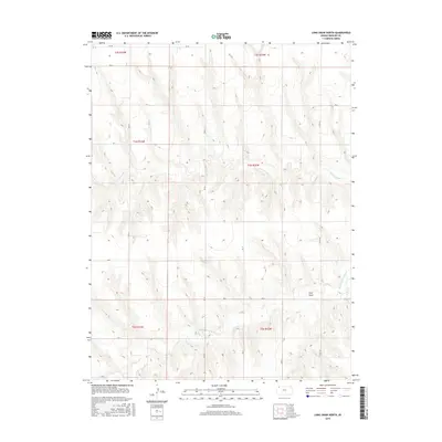
2015 Map of Long Draw North
USGS Topo · Published 2015About this map
N Fork Sappa Cr and Middle Fork Sappa Cr carve their way through the high plains of Rawlins County, defining the drainage patterns of this rural Kansas landscape. The terrain is characterized by the prominent Long Draw, a topographical feature that cuts through the eastern sections of the quadrangle. This 2015 survey reveals a sparse, systematic grid of section lines and county roads, such as Co Rd 444 and Rd 27, which provide access across the rolling breaks and upland plateaus. The map documents the enduring Public Land Survey System divisions, including t4s r32w and t4s r33w, illustrating how the western Kansas prairie remains partitioned for agricultural and ranching use. With very few structures indicated, the focus remains on the natural hydrology and the persistent road network that connects these isolated stretches of the High Plains.
Find a feature on this map
24 named features on this map. Tap any name to fly to it.
Don’t see what you’re looking for? This feature index may not catch every label — zoom into the map to look around manually.
Map Details
Editions of this 2015 Long Draw North Map
This is the sole edition of this map. No revisions or reprints were ever made.
Other maps of this area

1951 · Herndon
USGS Topo · 1:62,500

1951 · Achilles
USGS Topo · 1:62,500

1951 · Atwood
USGS Topo · 1:62,500

1951 · Chardon
USGS Topo · 1:62,500

1954 · Goodland
USGS Topo · 1:250,000

1956 · Goodland
USGS Topo · 1:250,000

1957 · Goodland
USGS Topo · 1:250,000

1965 · Achilles
USGS Topo · 1:24,000

1978 · Long Draw South
USGS Topo · 1:24,000
1978 · Atwood
USGS Topo · 1:24,000