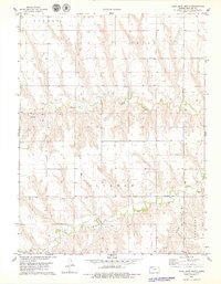
1978 Map of Long Draw North
USGS Topo · Published 1979About this map
North Fork Sappa Creek and Middle Fork Sappa Creek carve distinct paths through this northwestern Kansas landscape, defining the rural character of Rawlins County in the late 1970s. The map illustrates a highly organized township system, including portions of Atwood, Union, Arbor, Clinton, Achilles, and Jefferson. This period shows the continued agrarian and industrial utility of the land, marked by several Well and Oil Well locations, particularly in the western sections. The terrain is dominated by the namesake Long Draw, which feeds into the larger creek systems. Cultural details are sparse but significant for local history, including a lone Cem situated in the northern reaches of the quadrangle. The intricate network of section lines and unimproved roads reveals a landscape shaped by both natural drainage and the rigid geometry of the Public Land Survey System.
Find a feature on this map
14 named features on this map. Tap any name to fly to it.
Don’t see what you’re looking for? This feature index may not catch every label — zoom into the map to look around manually.
Map Details
Editions of this 1978 Long Draw North Map
This is the sole edition of this map. No revisions or reprints were ever made.
Other maps of this area

1951 · Herndon
USGS Topo · 1:62,500

1951 · Achilles
USGS Topo · 1:62,500

1951 · Atwood
USGS Topo · 1:62,500

1951 · Chardon
USGS Topo · 1:62,500

1954 · Goodland
USGS Topo · 1:250,000

1956 · Goodland
USGS Topo · 1:250,000

1957 · Goodland
USGS Topo · 1:250,000

1965 · Achilles
USGS Topo · 1:24,000

1978 · Long Draw South
USGS Topo · 1:24,000
1978 · Atwood
USGS Topo · 1:24,000