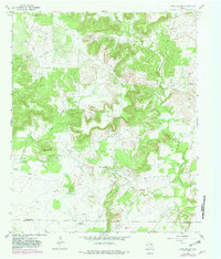
1967 Map of Long Hollow
USGS Topo · Published 1982About this map
The northern reaches of the Jack Co Palo Pinto Co line reveal a landscape transitioning from the cattle-ranching traditions of North Texas toward a mid-century energy economy. Numerous Oil Well sites are scattered throughout the hills, particularly concentrated near Deck Mountain. The presence of several family-named burial grounds, including the Halsell Ranch Cem and the Wood Cem, suggests a history of long-standing private landholdings and small family settlements. A localized settlement at Woolly and the nearby Landing Strip indicate the dual influence of traditional agricultural life and modern infrastructure. The hydrology of the area is defined by the branching tributaries of Salt Creek, with West Salt Creek and East Salt Creek carving through the terrain near the Long Hollow Cem.
Find a feature on this map
18 named features on this map. Tap any name to fly to it.
Don’t see what you’re looking for? This feature index may not catch every label — zoom into the map to look around manually.
Map Details
Editions of this 1967 Long Hollow Map
2 editions found
Other maps of this area

1891 · Palo Pinto
USGS Topo · 1:125,000

1918 · Palo Pinto
USGS Topo · 1:125,000

1924 · Palo Pinto 2-b
USGS Topo · 1:48,000

1924 · Palo Pinto 2-a
USGS Topo · 1:48,000

1924 · Palo Pinto 1-b
USGS Topo · 1:48,000

1927 · Pickwick
USGS Topo · 1:62,500

1927 · Mineral Wells
USGS Topo · 1:62,500

1954 · Abilene
USGS Topo · 1:250,000

1954 · Wichita Falls
USGS Topo · 1:250,000

1958 · Wichita Falls
USGS Topo · 1:250,000