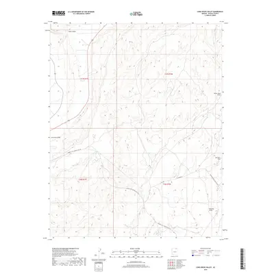
2018 Map of Long House Valley
USGS Topo · Published 2018About this map
Long House Valley and Wild Ram Valley dominate this landscape in Navajo County, where the infrastructure of the energy industry is clearly defined against the desert terrain. In the latter half of the 2010s, this region was characterized by the sprawling logistics network of the Peabody Western Coal Company, evidenced by the Peabody Coal Company Access Rd and the prominent Peabody Western Coal Haul Rd that cuts through the southeastern quadrant. The presence of these heavy industrial corridors, including a Haul Road and Haulage Road, illustrates the intersection of modern resource extraction with the traditional geography of the high desert. Hydrographic features like Beda Tohie, House Canyon, and Coal Mine Wash follow the natural drainage patterns of the valley floors, providing a stark contrast to the straight-line access roads and the rugged canyons such as Yellow Water Canyon.
Find a feature on this map
14 named features on this map. Tap any name to fly to it.
Don’t see what you’re looking for? This feature index may not catch every label — zoom into the map to look around manually.
Map Details
Editions of this 2018 Long House Valley Map
This is the sole edition of this map. No revisions or reprints were ever made.
Other maps of this area

1883 · Marsh Pass
USGS Topo · 1:250,000

1892 · Marsh Pass
USGS Topo · 1:250,000

1956 · Marble Canyon
USGS Topo · 1:250,000

1959 · Marble Canyon
USGS Topo · 1:250,000

1961 · Marble Canyon
USGS Topo · 1:250,000
1968 · Kayenta West
USGS Topo · 1:24,000

1968 · Marsh Pass
USGS Topo · 1:24,000

1968 · Yucca Hill
USGS Topo · 1:24,000
1968 · Marsh Pass SE
USGS Topo · 1:24,000

1970 · Shonto SE
USGS Topo · 1:24,000