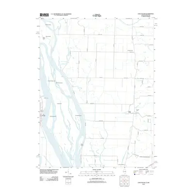
2012 Map of Long Island
USGS Topo · Published 2012About this map
Mississippi River braided channels dominate this landscape, creating a complex archipelago of landforms such as Long Island, La Grange Island, and Flannigan Island. On the Missouri side, the settlement of La Grange sits at the river's edge, marked by the mouth of the Wyaconda River and the nearby Oyster Br. The map reveals a distinct contrast between the river’s alluvial islands and the upland agriculture of the Illinois side, where a rigid grid of country roads connects sites like Campbell Farms. Local aviation is represented by both Schnelle Airport and the Blickhan Landing Area Airport, serving the rural communities along the river valley. Numerous secondary waterways like Frazier Cr and Rock Cr drain the eastern bluffs into the main channel, while backwaters like Goose Lake and Corner Slough highlight the shifting nature of the river's path.
Find a feature on this map
63 named features on this map. Tap any name to fly to it.
Don’t see what you’re looking for? This feature index may not catch every label — zoom into the map to look around manually.
Map Details
Editions of this 2012 Long Island Map
This is the sole edition of this map. No revisions or reprints were ever made.
Other maps of this area

1903 · Kahoka
USGS Topo · 1:125,000

1903 · Palmyra
USGS Topo · 1:125,000

1925 · Quincy
USGS Topo · 1:62,500

1944 · Quincy
USGS Topo · 1:62,500

1945 · Quincy
USGS Topo · 1:62,500

1946 · Mendon
USGS Topo · 1:62,500

1948 · Quincy
USGS Topo · 1:250,000

1948 · Mendon
USGS Topo · 1:62,500

1949 · Maywood
USGS Topo · 1:24,000
1950 · Maywood
USGS Topo · 1:24,000