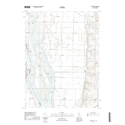
2018 Map of Long Island
USGS Topo · Published 2018About this map
La Grange, Missouri, sits at the western edge of this 2018 survey, where the Mississippi River forms a complex network of islands and side channels. The river’s shifting geography is defined by significant landmasses like the sprawling Long Island, which is separated from the Illinois shore by the Canton Chute. This riverine landscape is deeply shaped by drainage and navigation infrastructure, evidenced by the Main Ditch cutting through the lowlands north of Indian Grave Lake. On the eastern bluffs in Illinois, the settlement of Ursa marks the transition from the floodplains to higher agricultural ground.
Find a feature on this map
59 named features on this map. Tap any name to fly to it.
Don’t see what you’re looking for? This feature index may not catch every label — zoom into the map to look around manually.
Map Details
Editions of this 2018 Long Island Map
This is the sole edition of this map. No revisions or reprints were ever made.
Other maps of this area

1903 · Kahoka
USGS Topo · 1:125,000

1903 · Palmyra
USGS Topo · 1:125,000

1925 · Quincy
USGS Topo · 1:62,500

1944 · Quincy
USGS Topo · 1:62,500

1945 · Quincy
USGS Topo · 1:62,500

1946 · Mendon
USGS Topo · 1:62,500

1948 · Quincy
USGS Topo · 1:250,000

1948 · Mendon
USGS Topo · 1:62,500

1949 · Maywood
USGS Topo · 1:24,000
1950 · Maywood
USGS Topo · 1:24,000