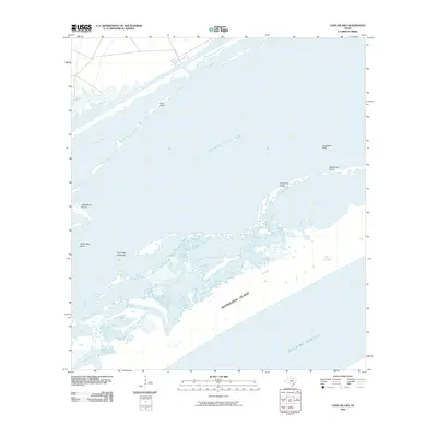
2010 Map of Long Island
USGS Topo · Published 2010About this map
Matagorda Island and the expansive waters of Espiritu Santo Bay dominate this coastal landscape, revealing the intricate network of barrier islands and tidal lakes that define the Texas Gulf Coast. The map detail shows the sprawling First Chain of Islands separating the bay from Long Lake, a labyrinthine region where water and land are in constant flux. Significant coastal landmarks such as Josephine Motte and the eponymous Long Island suggest a landscape used primarily for navigation and traditional coastal activities rather than dense habitation.
Find a feature on this map
20 named features on this map. Tap any name to fly to it.
Don’t see what you’re looking for? This feature index may not catch every label — zoom into the map to look around manually.
Map Details
Editions of this 2010 Long Island Map
This is the sole edition of this map. No revisions or reprints were ever made.
Other maps of this area

1952 · Mosquito Point
USGS Topo · 1:24,000

1952 · Pass Cavallo SW
USGS Topo · 1:24,000

1952 · Long Island
USGS Topo · 1:24,000

1952 · Seadrift NE
USGS Topo · 1:24,000

1952 · Panther Point
USGS Topo · 1:24,000

1952 · Seadrift
USGS Topo · 1:24,000
1952 · Panther Point NE
USGS Topo · 1:24,000

1952 · Port O'Connor
USGS Topo · 1:24,000

1953 · Beeville
USGS Topo · 1:250,000

1956 · Beeville
USGS Topo · 1:250,000