
1952 Map of Seadrift NE
USGS Topo · Published 1953About this map
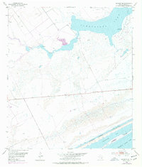
Powderhorn Lake and the surrounding marshy lowlands of coastal Calhoun County define this 1952 topographic study. The landscape is a complex of shallow water bodies and transition zones, where Coloma Creek feeds into the larger lake system before reaching the Gulf-facing waters. To the south, the Intracoastal Waterway cuts a straight, industrial line through the Mud Flat, separating the mainland from Shoalwater Bay and the protective strip of Dewberry Island in Espiritu Santo Bay.
Find a feature on this map
14 named features on this map. Tap any name to fly to it.
Don’t see what you’re looking for? This feature index may not catch every label — zoom into the map to look around manually.
Map Details
Editions of this 1952 Seadrift NE Map
2 editions found
Other maps of this area

1951 · Keller Bay
USGS Topo · 1:24,000

1952 · Port Lavaca East
USGS Topo · 1:24,000

1952 · Mosquito Point
USGS Topo · 1:24,000

1952 · Pass Cavallo SW
USGS Topo · 1:24,000

1952 · Long Island
USGS Topo · 1:24,000

1952 · Seadrift
USGS Topo · 1:24,000

1952 · Port Lavaca West
USGS Topo · 1:24,000

1952 · Port O'Connor
USGS Topo · 1:24,000

1953 · Beeville
USGS Topo · 1:250,000

1956 · Beeville
USGS Topo · 1:250,000