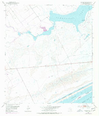
1952 Map of Seadrift NE
USGS Topo · Published 1976About this map
Powderhorn Lake Oil Field dominates the northeastern landscape of this coastal Texas region, where the intersection of petroleum industry and maritime geography is clearly defined. The terrain is characterized by extensive wetlands and low-lying coastal features, including the protected waters of Powderhorn Lake and the meandering path of Coloma Creek. A prominent Pipe Line and numerous Oil Wells illustrate the mid-century industrial footprint on the environment, while a Levee and various windmills suggest the ongoing efforts to manage water and livestock in this tidal zone. To the south, the Intracoastal Waterway cuts a straight path between the mainland and Dewberry Island, separating the inner marshes from the broader reaches of Shoalwater Bay and Espiritu Santo Bay. The 1973 revisions, marked in purple, record subtle changes in the shoreline and man-made structures over two decades.
Find a feature on this map
15 named features on this map. Tap any name to fly to it.
Don’t see what you’re looking for? This feature index may not catch every label — zoom into the map to look around manually.
Map Details
Editions of this 1952 Seadrift NE Map
2 editions found
Other maps of this area

1951 · Keller Bay
USGS Topo · 1:24,000

1952 · Port Lavaca East
USGS Topo · 1:24,000

1952 · Mosquito Point
USGS Topo · 1:24,000

1952 · Pass Cavallo SW
USGS Topo · 1:24,000

1952 · Long Island
USGS Topo · 1:24,000

1952 · Seadrift NE
USGS Topo · 1:24,000

1952 · Seadrift
USGS Topo · 1:24,000

1952 · Port Lavaca West
USGS Topo · 1:24,000

1952 · Port O'Connor
USGS Topo · 1:24,000

1953 · Beeville
USGS Topo · 1:250,000