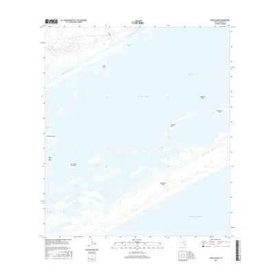
2016 Map of Long Island
USGS Topo · Published 2016About this map
Matagorda Island and the complex barrier systems of the Texas Gulf Coast define this maritime landscape in the mid-2010s. The area is a labyrinth of shallow bays and tidal features, where the Intracoastal Waterway cuts a straight path for commercial traffic through Shoalwater Bay and past Long Island. Navigational hazards and local landmarks like Josephine Reef and Josephine Motte punctuate the transition from the sheltered waters of Espiritu Santo Bay to the open Gulf of Mexico. The map documents a fragile coastal environment of low-lying landforms, including the First Chain of Islands and various passes such as Steamboat Pass. This configuration of inlets and marshes reflects the ongoing geological processes of the Calhoun County shoreline, providing a precise look at the bay-and-barrier island geography used by coastal mariners and environmental researchers.
Find a feature on this map
20 named features on this map. Tap any name to fly to it.
Don’t see what you’re looking for? This feature index may not catch every label — zoom into the map to look around manually.
Map Details
Editions of this 2016 Long Island Map
This is the sole edition of this map. No revisions or reprints were ever made.
Other maps of this area

1952 · Mosquito Point
USGS Topo · 1:24,000

1952 · Pass Cavallo SW
USGS Topo · 1:24,000

1952 · Long Island
USGS Topo · 1:24,000

1952 · Seadrift NE
USGS Topo · 1:24,000

1952 · Panther Point
USGS Topo · 1:24,000

1952 · Seadrift
USGS Topo · 1:24,000
1952 · Panther Point NE
USGS Topo · 1:24,000

1952 · Port O'Connor
USGS Topo · 1:24,000

1953 · Beeville
USGS Topo · 1:250,000

1956 · Beeville
USGS Topo · 1:250,000