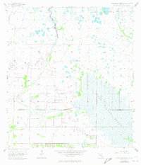
1956 Map of Long Island Marsh SW
USGS Topo · Published 1973About this map
The hydrological network of the Florida interior dominates this mid-century survey, centered on the transition between De Soto and Charlotte counties. The landscape is defined by an intricate system of wetlands and slow-moving water, most notably the expansive Long Island Marsh that occupies the southeastern portion of the quadrangle. Drainage patterns are articulated by numerous named water features, including the meandering Tiger Bay Slough and Prairie Creek, which feed into the broader marshland system.
Find a feature on this map
9 named features on this map. Tap any name to fly to it.
Don’t see what you’re looking for? This feature index may not catch every label — zoom into the map to look around manually.
Map Details
Editions of this 1956 Long Island Marsh SW Map
3 editions found
Other maps of this area

1956 · Arcadia SE
USGS Topo · 1:24,000

1956 · Telegraph Swamp NE
USGS Topo · 1:24,000

1956 · Telegraph Swamp NW
USGS Topo · 1:24,000

1956 · Long Island Marsh SW
USGS Topo · 1:24,000

1956 · Bermont
USGS Topo · 1:24,000

1956 · West Palm Beach
USGS Topo · 1:250,000

1956 · Fort Pierce
USGS Topo · 1:250,000

1957 · West Palm Beach
USGS Topo · 1:250,000

1957 · Long Island Marsh NW
USGS Topo · 1:24,000

1957 · Long Island Marsh SE
USGS Topo · 1:24,000