
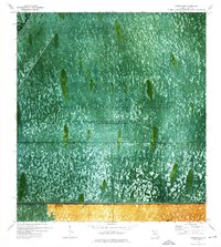
1973 Map of Long Island
USGS Topo · Published 1976About this map
John Buck Seminole Village and Little Doctor Seminole Village are situated among the distinct tree islands of the central Everglades in the early 1970s. This orthophotomap provides a rare visual of the land-and-water pattern of Everglades Wildlife Management Area Conservation Area No 3, where human habitation follows the natural elevations of hammocks like Long Island. The southern edge of the sheet is defined by the rigid line of the Tamiami Trail and the adjacent Tamiami Canal, which separate the managed conservation areas from the northern reaches of Everglades National Park. Other localized landmarks such as Sam Willies Camp and Indian Village appear near the Tamiami Trail, while network of recreational paths including Sand Point Trail, Hog Head Trail, and various Airboat Trails weave through the sawgrass and periodically impounded waters.
Find a feature on this map
26 named features on this map. Tap any name to fly to it.
Don’t see what you’re looking for? This feature index may not catch every label — zoom into the map to look around manually.
Map Details
Editions of this 1973 Long Island Map
This is the sole edition of this map. No revisions or reprints were ever made.
Other maps of this area

1956 · Miami
USGS Topo · 1:250,000

1958 · Miami
USGS Topo · 1:250,000

1972 · Shark Valley Lookout Tower
USGS Topo · 1:24,000

1972 · Chekika Island
USGS Topo · 1:24,000

1972 · South Of Coopertown
USGS Topo · 1:24,000

1973 · Fortymile Bend
USGS Topo · 1:24,000

1973 · Custard Apple Hammock
USGS Topo · 1:24,000

1973 · West Of Pennsuco
USGS Topo · 1:24,000
1973 · Coopertown
USGS Topo · 1:24,000
1973 · North of Fortymile Bend
USGS Topo · 1:24,000