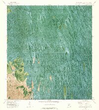
1973 Map of North of Fortymile Bend
USGS Topo · Published 1976About this map
Florida State Miccosukee Indian Reservation lands dominate the northern reaches of this orthophotomap, where the linear geometry of Levee 28 and the Levee 28 Tieback cuts through the organic patterns of the wet prairie. This 1970s aerial perspective reveals the human footprint in the Everglades, from the Airboat Trail network to small, localized settlements such as Mari Law Seminole Village and Sam Willie Seminole Village. The landscape is defined by the hydrologic management of Conservation Area No 3A, where water is impounded periodically to sustain the surrounding Everglades Wildlife Management Area. Notable landmarks like Choctaw Hammock and the site of Sam Franks Old Farm provide specific points of reference within the mosaic of vegetation and water, illustrating the historical use of high ground in a region defined by its inundation.
Find a feature on this map
15 named features on this map. Tap any name to fly to it.
Don’t see what you’re looking for? This feature index may not catch every label — zoom into the map to look around manually.
Map Details
Editions of this 1973 North of Fortymile Bend Map
2 editions found
Other maps of this area

1956 · Miami
USGS Topo · 1:250,000

1956 · West Palm Beach
USGS Topo · 1:250,000

1957 · West Palm Beach
USGS Topo · 1:250,000

1958 · West Palm Beach
USGS Topo · 1:250,000

1958 · Miami
USGS Topo · 1:250,000

1973 · Fortymile Bend
USGS Topo · 1:24,000

1973 · Custard Apple Hammock
USGS Topo · 1:24,000

1973 · Fiftymile Bend
USGS Topo · 1:24,000

1973 · North Of Fiftymile Bend
USGS Topo · 1:24,000

1973 · Long Island
USGS Topo · 1:24,000