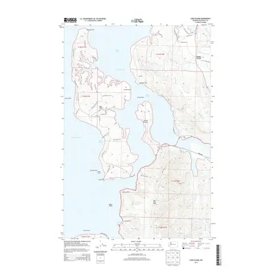
2014 Map of Long Island
USGS Topo · Published 2014About this map
Long Island dominates this coastal landscape at the eastern edge of Willapa Bay, separated from the mainland by the Stanley Channel and Nahcotta Channel. On the mainland to the east, the settlement of Middle Nemah sits near the confluence of the Middle Nemah River and S-Nemah River, while scattered homesteads and agricultural operations like Lagergren Ranch and Mill Ranch are positioned along the shoreline and interior valleys. The terrain is defined by a network of tidal inlets, including Chetlo Harbor and Seal Slough, which cut into the rising timberlands of Bear River Ridge. Extensive trail systems, such as the Center Road Trail and Paradise Point Trail, weave across Long Island, providing access to landmarks like Smoky Hollow and Pinnacle Rock. This survey documents a complex shoreline of points and sloughs, from Diamond Point in the north to Porter Point at the southern reach of the bay.
Find a feature on this map
60 named features on this map. Tap any name to fly to it.
Don’t see what you’re looking for? This feature index may not catch every label — zoom into the map to look around manually.
Map Details
Editions of this 2014 Long Island Map
This is the sole edition of this map. No revisions or reprints were ever made.
Other maps of this area

1938 · Cape Disappointment
USGS Topo · 1:62,500

1938 · Cape Shoalwater
USGS Topo · 1:62,500

1938 · Fort Columbia
USGS Topo · 1:62,500

1938 · South Bend
USGS Topo · 1:62,500

1940 · South Bend
USGS Topo · 1:62,500

1943 · Fort Columbia
USGS Topo · 1:62,500

1943 · Copalis Beach
USGS Topo · 1:250,000

1949 · Chinook
USGS Topo · 1:24,000

1949 · Oman Ranch
USGS Topo · 1:24,000

1949 · Knappton
USGS Topo · 1:24,000