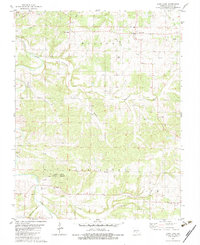
1982 Map of Long Lane
USGS Topo · Published 1983About this map
Niangua River and Dousinbury Creek carve through the landscape of Dallas County, Missouri, in this early 1980s topographic survey. The area is defined by small, dispersed rural settlements and local religious landmarks, including New Prospect Ch and Liberty Ch, which often served as the social hubs for surrounding farmsteads. The settlement of Long Lane is a primary node, while smaller locales like Earnestville, Handley, and the curiously named Wall Street reflect the historical rural geography of the Ozarks.
Find a feature on this map
27 named features on this map. Tap any name to fly to it.
Don’t see what you’re looking for? This feature index may not catch every label — zoom into the map to look around manually.
Map Details
Editions of this 1982 Long Lane Map
This is the sole edition of this map. No revisions or reprints were ever made.
Other maps of this area

1884 · Springfield
USGS Topo · 1:125,000

1884 · Bolivar
USGS Topo · 1:125,000

1886 · Springfield
USGS Topo · 1:125,000

1892 · Bolivar
USGS Topo · 1:125,000

1939 · Long Lane
USGS Topo · 1:62,500

1942 · Long Lane
USGS Topo · 1:62,500

1946 · Niangua
USGS Topo · 1:62,500

1947 · Strafford
USGS Topo · 1:62,500

1948 · Niangua
USGS Topo · 1:62,500

1948 · Strafford
USGS Topo · 1:62,500