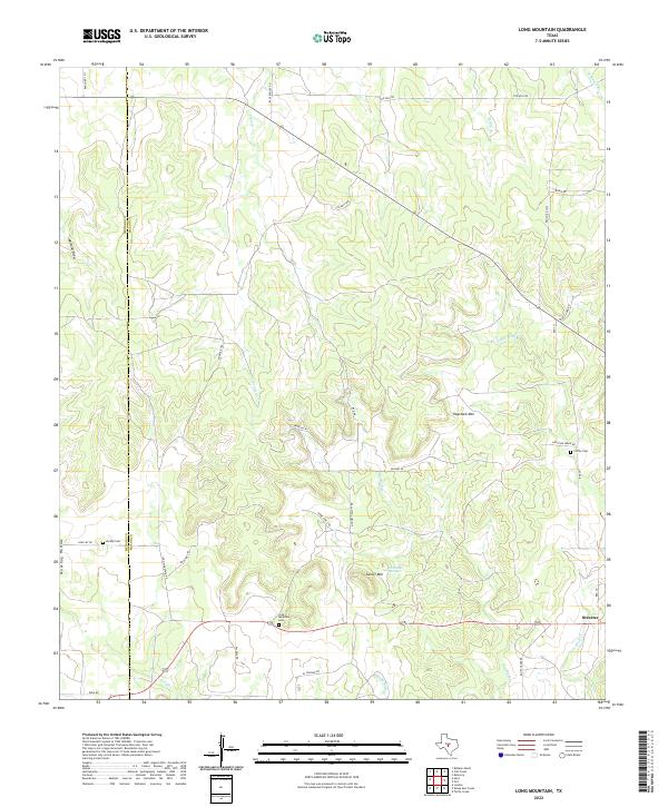
2022 Map of Long Mountain
USGS Topo · Published 2022About this map
The boundary of Menard Co and Mason Co bisects this ranching landscape in the Texas Hill Country, where the small settlement of Streeter serves as a lone hub of activity. The terrain is defined by dramatic rises and drainage systems, featuring landmarks like Haystack Mtn and Cutoff Mtn, alongside the intermittent flow of Tenmile Cr and Big Bluff Cr. For those researching family history, several burial sites are preserved across the rangeland, including the Long Mountain Cem, Jacoby Cem, and Coffey Cem. The map reveals a network of rural routes such as Ranch Rd 1311 and Rooster Trl that navigate the varied elevations of Muskhog Hollow and the surrounding draws. Pluenneke Springs stands out as a vital water source in this dry environment, typical of the historic cattle country west of Mason.
Find a feature on this map
38 named features on this map. Tap any name to fly to it.
Don’t see what you’re looking for? This feature index may not catch every label — zoom into the map to look around manually.
Map Details
Editions of this 2022 Long Mountain Map
This is the sole edition of this map. No revisions or reprints were ever made.
Other maps of this area

1887 · Mason
USGS Topo · 1:125,000

1894 · Mason
USGS Topo · 1:125,000

1954 · Llano
USGS Topo · 1:250,000

1955 · Llano
USGS Topo · 1:250,000

1956 · Llano
USGS Topo · 1:250,000
1968 · Turtle Creek
USGS Topo · 1:24,000

1968 · Sheep Run Creek
USGS Topo · 1:24,000

1968 · London
USGS Topo · 1:24,000
1970 · Calf Creek
USGS Topo · 1:24,000
1970 · Katemcy
USGS Topo · 1:24,000