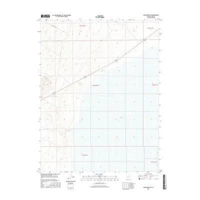
2017 Map of Long Ridge SW
USGS Topo · Published 2017About this map
The arid landscape of Millard County is defined here by the vast expanse of Sevier Lake, a terminal desert lakebed that dominates the eastern portion of this 2017 study. The interaction between sparse water resources and the desert floor is evidenced by a series of catchment features, including Mud Flat Reservoir and Sevier Lake Reservoir Number 1. These small-scale water management sites are critical infrastructure in such a dry environment, positioned to capture seasonal runoff before it reaches the saline flats. To the west, the terrain transitions toward the elevations of Miller Canyon, where Miller Canyon Reservoir sits near the head of a drainage system. The area remains largely undeveloped, navigated only by utility and access routes like Miller Canyon Rd and Jc Rd, which trace the contours between the high ground and the lake basin.
Find a feature on this map
13 named features on this map. Tap any name to fly to it.
Don’t see what you’re looking for? This feature index may not catch every label — zoom into the map to look around manually.
Map Details
Editions of this 2017 Long Ridge SW Map
This is the sole edition of this map. No revisions or reprints were ever made.
Other maps of this area

1908 · Fish Springs
USGS Topo · 1:250,000

1910 · Fish Springs
USGS Topo · 1:250,000

1953 · Richfield
USGS Topo · 1:250,000

1953 · Delta
USGS Topo · 1:250,000

1958 · Richfield
USGS Topo · 1:250,000

1958 · Delta
USGS Topo · 1:250,000

1960 · Notch Peak
USGS Topo · 1:62,500

1960 · The Barn
USGS Topo · 1:62,500

1962 · Delta
USGS Topo · 1:250,000
1972 · Long Ridge
USGS Topo · 1:24,000