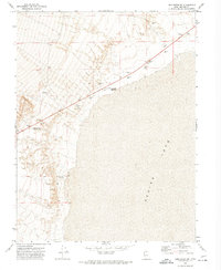
1972 Map of Long Ridge SW
USGS Topo · Published 1974About this map
Sevier Lake dominates the eastern half of this Millard County landscape, showcasing its vast, flat expanse at the base of the surrounding ridges. Along the western shoreline and climbing into the higher terrain, a series of water management features indicate the effort to capture runoff in this arid environment. Key sites include Mud Flat Reservoir, Sevier Lake Reservoir No 1, and Miller Canyon Reservoir, which serve as critical landmarks for local water rights and land use history. The topography is further marked by resource extraction, noted by numerous Borrow Pits and a Borrow Pit following the line of a light-duty road through the North End of the valley. These features, along with established fence lines and benchmark elevations, provide a precise record of the regional infrastructure as it existed in the early 1970s.
Find a feature on this map
11 named features on this map. Tap any name to fly to it.
Don’t see what you’re looking for? This feature index may not catch every label — zoom into the map to look around manually.
Map Details
Editions of this 1972 Long Ridge SW Map
This is the sole edition of this map. No revisions or reprints were ever made.
Other maps of this area

1908 · Fish Springs
USGS Topo · 1:250,000

1910 · Fish Springs
USGS Topo · 1:250,000

1953 · Richfield
USGS Topo · 1:250,000

1953 · Delta
USGS Topo · 1:250,000

1958 · Richfield
USGS Topo · 1:250,000

1958 · Delta
USGS Topo · 1:250,000

1960 · Notch Peak
USGS Topo · 1:62,500

1960 · The Barn
USGS Topo · 1:62,500

1962 · Delta
USGS Topo · 1:250,000
1972 · Long Ridge
USGS Topo · 1:24,000