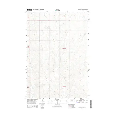
2015 Map of Longbrake Ranch
USGS Topo · Published 2015About this map
Longbrake Ranch sits at the heart of this rangeland in Ziebach County, illustrating the enduring nature of remote livestock operations in South Dakota’s West River region. The landscape is defined by a dendritic drainage network that feeds into Ash Cr, including the W Br Ash Cr and Girl Cr to the north. These intermittent waterways and the presence of Herren Dam highlight the vital role of water management in an area dominated by high plains topography. To the southwest, Rattlesnake Cr carves through the terrain, marking the transition toward more dissected ground. The map reflects a modern view of traditional land use, where section lines and isolated ranch steadings remain the primary features of human geography in this expansive prairie environment.
Find a feature on this map
12 named features on this map. Tap any name to fly to it.
Don’t see what you’re looking for? This feature index may not catch every label — zoom into the map to look around manually.
Map Details
Editions of this 2015 Longbrake Ranch Map
This is the sole edition of this map. No revisions or reprints were ever made.
Other maps of this area

1954 · Pierre
USGS Topo · 1:250,000

1955 · Rattlesnake Lake
USGS Topo · 1:24,000

1955 · Rattlesnake Lake NE
USGS Topo · 1:24,000

1958 · Pierre
USGS Topo · 1:250,000

1982 · Bull Creek 2 NE
USGS Topo · 1:24,000

1982 · Bridger NE
USGS Topo · 1:24,000

1982 · Red Scaffold
USGS Topo · 1:24,000

1982 · Miller Dam
USGS Topo · 1:24,000

1982 · Longbrake Ranch
USGS Topo · 1:24,000
1982 · Diermier Ranch
USGS Topo · 1:24,000