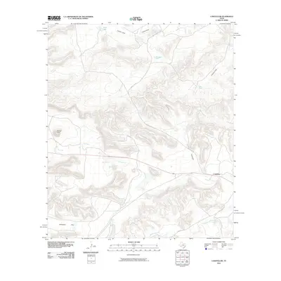
2010 Map of Longfellow
USGS Topo · Published 2010About this map
Longfellow sits as a lonely outpost in this arid Trans-Pecos landscape, where the terrain is defined by a network of seasonal watercourses and prominent local peaks. The settlement is positioned along a corridor of activity that includes the winding path of Longfellow Rd and the intermittent flow of Dry Creek. To the west, the topography rises sharply at Panther Peak, while the southern reaches of the quadrangle level out into the appropriately named Rattlesnake Flats.
Find a feature on this map
14 named features on this map. Tap any name to fly to it.
Don’t see what you’re looking for? This feature index may not catch every label — zoom into the map to look around manually.
Map Details
Editions of this 2010 Longfellow Map
This is the sole edition of this map. No revisions or reprints were ever made.
Other maps of this area

1920 · Longfellow
USGS Topo · 1:125,000

1954 · Fort Stockton
USGS Topo · 1:250,000

1958 · Fort Stockton
USGS Topo · 1:250,000

1968 · Cap Rock Butte
USGS Topo · 1:24,000

1968 · Big Brindle Canyon
USGS Topo · 1:24,000

1968 · Toms Canyon
USGS Topo · 1:24,000

1968 · F C Ranch
USGS Topo · 1:24,000

1968 · Fresno Creek
USGS Topo · 1:24,000

1968 · Longfellow
USGS Topo · 1:24,000
1968 · Tesnus SE
USGS Topo · 1:24,000