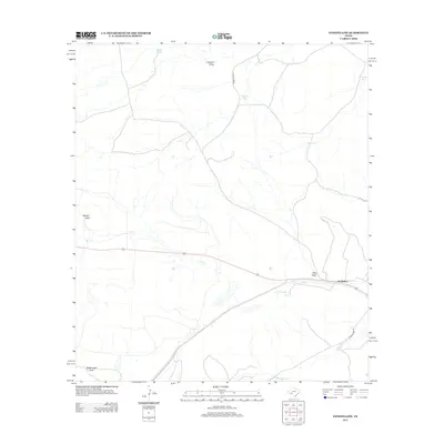
2012 Map of Longfellow
USGS Topo · Published 2012About this map
Longfellow sits as the central settlement point in this arid stretch of Pecos County, where the infrastructure of the rail line and Longfellow Rd intersect the desert floor. The landscape is defined by its drainage patterns, with Javelina Draw and Yolts Draw carving pathways through the terrain toward Sanderson Cr. Water management is a critical feature of this ranching country, evidenced by numerous named catchments such as Haystack Tank, Fortyone Tank, and Gap Tank, which sustain life between seasonal rains.
Find a feature on this map
12 named features on this map. Tap any name to fly to it.
Don’t see what you’re looking for? This feature index may not catch every label — zoom into the map to look around manually.
Map Details
Editions of this 2012 Longfellow Map
This is the sole edition of this map. No revisions or reprints were ever made.
Other maps of this area

1920 · Longfellow
USGS Topo · 1:125,000

1954 · Fort Stockton
USGS Topo · 1:250,000

1958 · Fort Stockton
USGS Topo · 1:250,000

1968 · Cap Rock Butte
USGS Topo · 1:24,000

1968 · Big Brindle Canyon
USGS Topo · 1:24,000

1968 · Toms Canyon
USGS Topo · 1:24,000

1968 · F C Ranch
USGS Topo · 1:24,000

1968 · Fresno Creek
USGS Topo · 1:24,000

1968 · Longfellow
USGS Topo · 1:24,000
1968 · Tesnus SE
USGS Topo · 1:24,000