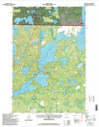
1996 Map of Longville
USGS Topo · Published 1998About this map
Longville serves as the focal point of this northern Minnesota landscape, where the waters of Girl Lake and Leech Lake meet. The geography is defined by an intricate network of interconnected waterways, including the expansive Little Boy Lake and Wabedo Lake. These features are set within the overlapping boundaries of the Chippewa National Forest and the Leech Lake Indian Reservation, illustrating the complex land management of the region. Local infrastructure such as the Longville Municipal Airport and the Wabedo Cemetery provide key reference points for genealogy and local history research. The presence of Camp Olson and numerous boat ramps emphasizes the area's long-standing role as a destination for outdoor recreation and seasonal settlement. From the smaller basins of Nellie Lake to the southern reaches of Blind Lake, the map captures a specific moment in the hydraulic and social history of Cass County.
Find a feature on this map
45 named features on this map. Tap any name to fly to it.
Don’t see what you’re looking for? This feature index may not catch every label — zoom into the map to look around manually.
Map Details
Editions of this 1996 Longville Map
This is the sole edition of this map. No revisions or reprints were ever made.
Other maps of this area

1953 · Brainerd
USGS Topo · 1:250,000

1954 · Bemidji
USGS Topo · 1:250,000

1957 · Brainerd
USGS Topo · 1:250,000

1957 · Bemidji
USGS Topo · 1:250,000

1958 · Bemidji
USGS Topo · 1:250,000

1958 · Brainerd
USGS Topo · 1:250,000

1965 · Brainerd
USGS Topo · 1:250,000

1970 · Laura Lake
USGS Topo · 1:24,000
1970 · Mitchell Lake
USGS Topo · 1:24,000

1970 · Woman Lake
USGS Topo · 1:24,000