
1970 Map of Laura Lake
USGS Topo · Published 1972About this map
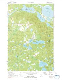
Chippewa National Forest and Land O'Lakes State Forest dominate this section of Cass County, defined by an intricate network of glacial lakes and waterways. The landscape in 1970 shows the managed intersection of timberlands and recreational waters, with Laura Lake and Remer situated in the northeast. A series of interconnected basins including Lower Trelipe Lake and Upper Trelipe Lake drain via Trelipe Creek into Inguadona Lake. To the south, the terrain becomes increasingly dense with smaller water bodies like Mitten Lake, Island Lake, and the aptly named Lake Twentysix. Natural drainage patterns are marked by Daggett Brook, which winds through the central marshes toward Washburn Lake. This period of the forest's history is noted for its gravel resources, with several Gravel Pits mapped near the shorelines of Little Bass Lake and Lake Twentysix.
Find a feature on this map
23 named features on this map. Tap any name to fly to it.
Don’t see what you’re looking for? This feature index may not catch every label — zoom into the map to look around manually.
Map Details
Editions of this 1970 Laura Lake Map
2 editions found
Other maps of this area

1953 · Duluth
USGS Topo · 1:250,000

1953 · Brainerd
USGS Topo · 1:250,000

1954 · Bemidji
USGS Topo · 1:250,000

1954 · Hibbing
USGS Topo · 1:250,000

1957 · Brainerd
USGS Topo · 1:250,000

1957 · Bemidji
USGS Topo · 1:250,000

1957 · Hibbing
USGS Topo · 1:250,000

1958 · Bemidji
USGS Topo · 1:250,000

1958 · Hibbing
USGS Topo · 1:250,000

1958 · Brainerd
USGS Topo · 1:250,000