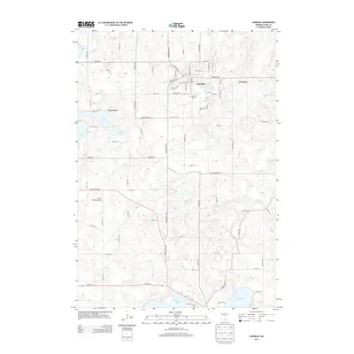
2013 Map of Lonsdale
USGS Topo · Published 2013About this map
Lonsdale serves as the primary hub in this portion of Rice County, exhibiting a distinct grid of streets like Central St W and Main St S. To the west, the settlement of Wheatland sits near Cody Lake, while Trondjem is situated to the east. The landscape is dotted with several significant water bodies, including Shields Lake and Mazaska Lake along the southern edge, and Phelps Lake to the west. This 2013 data illustrates a rural landscape where aviation and local heritage intersect, shown by the Tuma Private Airport and historic burial grounds such as Calvary Hill Cem and Saint Johns Cem. The region is crisscrossed by a dense network of numbered west-east roads, from 70th St W in the north to 143rd St W near the southern lakeshore, which facilitate movement between the area's agricultural tracts and small community centers.
Find a feature on this map
63 named features on this map. Tap any name to fly to it.
Don’t see what you’re looking for? This feature index may not catch every label — zoom into the map to look around manually.
Map Details
Editions of this 2013 Lonsdale Map
This is the sole edition of this map. No revisions or reprints were ever made.
Other maps of this area

1953 · Saint Paul
USGS Topo · 1:250,000

1957 · Prior Lake
USGS Topo · 1:62,500

1957 · New Prague
USGS Topo · 1:62,500

1959 · Saint Paul
USGS Topo · 1:250,000

1960 · Faribault
USGS Topo · 1:24,000

1960 · Shieldsville
USGS Topo · 1:24,000

1960 · Lonsdale
USGS Topo · 1:24,000

1960 · Little Chicago
USGS Topo · 1:24,000

1966 · Montgomery
USGS Topo · 1:24,000
1966 · Kilkenny
USGS Topo · 1:24,000