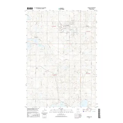
2016 Map of Lonsdale
USGS Topo · Published 2016About this map
Lonsdale stands as a central hub in this Rice County landscape, characterized by a transition from organized municipal streets to a wide-reaching agricultural grid. The town's growth is evident in the residential developments along Singing Hills Dr and Willow Creek Dr SE, while the surrounding countryside maintains its rural identity through small settlements like Wheatland and Trondjem. A series of significant glacial lakes, including Metogga Lake, Cody Lake, and Mazaska Lake, dot the terrain, influencing the layout of local roads such as Co Rd 2 and the Union Lake Trl. Local heritage is preserved at sites like Calvary Hill Cem near the city center and Saint Johns Cem to the southeast. The inclusion of the Tuma Private Airport reflects the continued use of private aviation infrastructure within this farming community during the mid-2010s.
Find a feature on this map
82 named features on this map. Tap any name to fly to it.
Don’t see what you’re looking for? This feature index may not catch every label — zoom into the map to look around manually.
Map Details
Editions of this 2016 Lonsdale Map
This is the sole edition of this map. No revisions or reprints were ever made.
Other maps of this area

1953 · Saint Paul
USGS Topo · 1:250,000

1957 · Prior Lake
USGS Topo · 1:62,500

1957 · New Prague
USGS Topo · 1:62,500

1959 · Saint Paul
USGS Topo · 1:250,000

1960 · Faribault
USGS Topo · 1:24,000

1960 · Shieldsville
USGS Topo · 1:24,000

1960 · Lonsdale
USGS Topo · 1:24,000

1960 · Little Chicago
USGS Topo · 1:24,000

1966 · Montgomery
USGS Topo · 1:24,000
1966 · Kilkenny
USGS Topo · 1:24,000