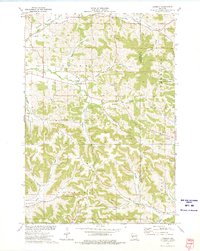
1973 Map of Lookout
USGS Topo · Published 1975About this map
Deep ravines and narrow ridges define the borderlands of Buffalo and Trempealeau counties in the early 1970s. The settlement of Lookout serves as a central anchor for a landscape of small farmsteads and rural parish life, evidenced by the numerous family and church cemeteries like Cooke Cem and Julson Cem that dot the valley floors. The terrain is a complex network of named valleys, including Happy Valley, Rainbow Valley, and Silver Fox Valley, which channel local traffic between the high ground of Montana Ridge and the South Fork Elk Creek. This period shows the region's agricultural character preserved alongside managed conservation at the Borst Valley State Public Hunting Area. Small-scale industry is present through scattered quarries on the hillsides, while spiritual life is anchored by Good Shepherd Ch and Evanger Ch.
Find a feature on this map
41 named features on this map. Tap any name to fly to it.
Don’t see what you’re looking for? This feature index may not catch every label — zoom into the map to look around manually.
Map Details
Editions of this 1973 Lookout Map
This is the sole edition of this map. No revisions or reprints were ever made.
Other maps of this area

1926 · Whitehall
USGS Topo · 1:62,500

1927 · Strum
USGS Topo · 1:62,500

1929 · Whitehall
USGS Topo · 1:62,500

1930 · Strum
USGS Topo · 1:62,500

1932 · Gilmanton
USGS Topo · 1:62,500

1932 · Mondovi
USGS Topo · 1:62,500

1953 · Eau Claire
USGS Topo · 1:250,000

1958 · Eau Claire
USGS Topo · 1:250,000

1964 · Eau Claire
USGS Topo · 1:250,000
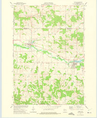
1973 · Strum
USGS Topo · 1:24,000