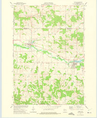
1973 Map of Strum
USGS Topo · Published 1975About this map
The Buffalo River valley serves as the primary corridor for settlement and industry in this portion of Trempealeau County, following a northwest-to-southeast path through the landscape. The Chicago and North Western railroad parallels the river, connecting the village of Eleva to the larger community of Strum. This rail-and-river network supported a local economy of agriculture and resource extraction, evidenced by numerous gravel pits and sandpits along the valley floor. Educational and civic infrastructure is clustered around these nodes, including the Central Area High Sch located between the two settlements. To the south, the terrain becomes more varied as it rises toward Bennett Ridge. This area is defined by a series of named drainages like Trout Creek and Chimney Rock Creek, which flow through valleys such as Berg Valley and Adams Valley. The southern portion of the sheet also features the Chimney Rock State Public Hunting Grounds, indicating a transition from the industrial valley floor to managed natural spaces and quarries.
Find a feature on this map
40 named features on this map. Tap any name to fly to it.
Don’t see what you’re looking for? This feature index may not catch every label — zoom into the map to look around manually.
Map Details
Editions of this 1973 Strum Map
This is the sole edition of this map. No revisions or reprints were ever made.
Other maps of this area

1926 · Whitehall
USGS Topo · 1:62,500

1927 · Strum
USGS Topo · 1:62,500

1929 · Whitehall
USGS Topo · 1:62,500

1930 · Strum
USGS Topo · 1:62,500

1932 · Gilmanton
USGS Topo · 1:62,500

1932 · Mondovi
USGS Topo · 1:62,500

1953 · Eau Claire
USGS Topo · 1:250,000

1958 · Eau Claire
USGS Topo · 1:250,000

1964 · Eau Claire
USGS Topo · 1:250,000
1973 · Cleghorn
USGS Topo · 1:24,000