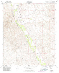
1949 Map of Lookout Mtn
USGS Topo · Published 1985About this map
The Old Camp Grant Military Reservation (Abandoned) defines the historical footprint of this Pinal County landscape, with its diagonal boundary cutting across the valley of the San Pedro River. This mid-century survey captures the region just as revisions were being noted in the 1970s, showing a transition from early ranching and military presence to a more modern infrastructure. The Pz Ranch and several well sites represent the localized agriculture and water management essential to this arid environment.
Find a feature on this map
16 named features on this map. Tap any name to fly to it.
Don’t see what you’re looking for? This feature index may not catch every label — zoom into the map to look around manually.
Map Details
Editions of this 1949 Lookout Mtn Map
3 editions found
Other maps of this area

1911 · Winkelman
USGS Topo · 1:125,000

1913 · Winkelman
USGS Topo · 1:125,000

1948 · Clark Ranch
USGS Topo · 1:24,000

1948 · Mammoth
USGS Topo · 1:62,500

1948 · Mammoth
USGS Topo · 1:24,000

1949 · Clark Ranch
USGS Topo · 1:24,000

1949 · Mammoth
USGS Topo · 1:24,000

1949 · Holy Joe Peak
USGS Topo · 1:62,500

1949 · Winkelman
USGS Topo · 1:24,000

1949 · Winkelman
USGS Topo · 1:62,500