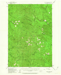
1953 Map of Lookout Mtn
USGS Topo · Published 1963About this map
Gifford Pinchot National Forest dominates this mid-century topographical study of the Skamania County wilderness. The landscape is defined by the volcanic history of the region, evident in the prominent Lava flows and peaks like West Crater and Trout Creek Hill. Strategic fire lookout and administrative points such as Sunset Guard Station, Lookout Mtn, and Green Lookout Mtn mark the high ridges, overlooking a complex drainage system led by the East Fork Lewis River and Siouxon Creek. Recreational and scientific land use is visible at Government Mineral Springs and the Wind River Experimental Forest, while remote peaks like Calamity Peak and Siouxon Pk indicate the challenging terrain. This era of the forest shows an established network of trails and service roads supporting both timber management and early backcountry tourism.
Find a feature on this map
80 named features on this map. Tap any name to fly to it.
Don’t see what you’re looking for? This feature index may not catch every label — zoom into the map to look around manually.
Map Details
Editions of this 1953 Lookout Mtn Map

Other maps of this area

1918 · Troutdale
USGS Topo · 1:62,500

1919 · Mount St Helens
USGS Topo · 1:125,000

1926 · Steamboat Mtn
USGS Topo · 1:125,000

1926 · Hood River
USGS Topo · 1:125,000

1929 · Hood River
USGS Topo · 1:125,000

1931 · Steamboat Mtn
USGS Topo · 1:125,000

1934 · Troutdale
USGS Topo · 1:48,000

1940 · Lookout Mtn
USGS Topo · 1:62,500

1941 · Yacolt
USGS Topo · 1:62,500

1941 · Camas
USGS Topo · 1:62,500