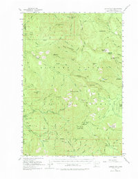
1953 Map of Lookout Mtn
USGS Topo · Published 1975About this map
Gifford Pinchot National Forest dominates this mid-century landscape, revealing a complex network of fire lookouts and forest service infrastructure in the mountains of Skamania and Clark counties. The survey highlights the intersection of resource management and early recreation, evidenced by the Sunset Guard Station and established campsites like Springs Camp. The terrain is defined by dramatic peaks and deep river drainages, from the East Fork Lewis River to the Washougal River. Geologic features such as the West Crater and Soda Peaks sit alongside evidence of local industry at Miners Mine. Near the eastern boundary, Government Mineral Springs indicates the historical value of the area's natural waters, while the Wind River Experimental Forest represents the era's scientific approach to silviculture.
Find a feature on this map
77 named features on this map. Tap any name to fly to it.
Don’t see what you’re looking for? This feature index may not catch every label — zoom into the map to look around manually.
Map Details
Editions of this 1953 Lookout Mtn Map

Other maps of this area

1918 · Troutdale
USGS Topo · 1:62,500

1919 · Mount St Helens
USGS Topo · 1:125,000

1926 · Steamboat Mtn
USGS Topo · 1:125,000

1926 · Hood River
USGS Topo · 1:125,000

1929 · Hood River
USGS Topo · 1:125,000

1931 · Steamboat Mtn
USGS Topo · 1:125,000

1934 · Troutdale
USGS Topo · 1:48,000

1940 · Lookout Mtn
USGS Topo · 1:62,500

1941 · Yacolt
USGS Topo · 1:62,500

1941 · Camas
USGS Topo · 1:62,500