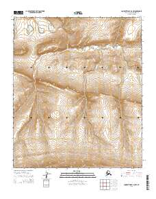
2015 Map of Lookout Ridge A-5 NW
USGS Topo · Published 2015About this map
Carbon Creek meanders through the northern reaches of this North Slope landscape, providing a primary drainage feature for the surrounding terrain. This U.S. Geological Survey topographic study reflects the high-latitude geography of the region as documented in the early twenty-first century, specifically within the public land survey system divisions of t2s r29w and t2s r28w. The contour data from the National Elevation Dataset reveals a gradual elevation rise toward the south, where the ridges become more pronounced in townships like t4s r29w. While the area is devoid of permanent settlements or infrastructure, the map serves as a precise record of the natural hydrology and topographical contours of the Arctic tundra environment.
Find a feature on this map
7 named features on this map. Tap any name to fly to it.
Don’t see what you’re looking for? This feature index may not catch every label — zoom into the map to look around manually.
Map Details
Editions of this 2015 Lookout Ridge A-5 NW Map
This is the sole edition of this map. No revisions or reprints were ever made.
Other maps of this area

1951 · Utukok River
USGS Topo · 1:250,000

1951 · Lookout Ridge
USGS Topo · 1:250,000

1956 · Lookout Ridge
USGS Topo · 1:250,000

1956 · Utukok River
USGS Topo · 1:250,000

1965 · Utukok River
USGS Topo · 1:250,000
1984 · Utukok River A-1
USGS Topo · 1:63,360
1984 · Lookout Ridge A-5
USGS Topo · 1:63,360
1985 · Lookout Ridge B-5
USGS Topo · 1:63,360
1985 · Utukok River B-1
USGS Topo · 1:63,360
2015 · Lookout Ridge B-5 SE
USGS Topo · 1:25,000