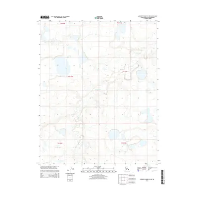
2015 Map of Lookout Ridge D-2 NE
USGS Topo · Published 2015About this map
Usuktuk River winds through this expanse of the North Slope, serving as the primary geographic feature within the Lookout Ridge D-2 NE quadrangle. This 2015 survey reveals a landscape defined by an intricate network of lakes and drainage patterns typical of the Arctic tundra, mapped here during a period of modern geospatial documentation. The land is organized by the Public Land Survey System, with grid lines for Townships 6 through 8 North and Ranges 19 and 20 West providing the only formal structure across the open terrain. The absence of roads or permanent settlements in this sector reflects the true character of the remote Alaskan interior, where the serpentine path of the river dictates the topography and likely historic routes for seasonal travel.
Find a feature on this map
7 named features on this map. Tap any name to fly to it.
Don’t see what you’re looking for? This feature index may not catch every label — zoom into the map to look around manually.
Map Details
Editions of this 2015 Lookout Ridge D-2 NE Map
This is the sole edition of this map. No revisions or reprints were ever made.
Other maps of this area

1951 · Meade River
USGS Topo · 1:250,000

1951 · Lookout Ridge
USGS Topo · 1:250,000

1955 · Meade River
USGS Topo · 1:250,000

1955 · Meade River A-2
USGS Topo · 1:63,360
1955 · Meade River A-1
USGS Topo · 1:63,360

1956 · Lookout Ridge
USGS Topo · 1:250,000
1984 · Lookout Ridge D-1
USGS Topo · 1:63,360
1984 · Lookout Ridge D-2
USGS Topo · 1:63,360
2015 · Meade River A-2 SW
USGS Topo · 1:25,000
2015 · Lookout Ridge D-2 SE
USGS Topo · 1:25,000