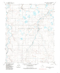
1984 Map of Lookout Ridge D-2
USGS Topo · Published 1985About this map
The National Petroleum Reserve in Alaska dominates this 1980s landscape, illustrating a period of intensive geological study across the North Slope. The terrain is defined by complex hydrologic networks, most notably the meandering course of the Meade River as it cuts through the western portion of the quadrangle. In the central and eastern sections, the Usuktuk River and Piksiksak Creek create a dense pattern of oxbows and riparian wetlands. Human presence is sparse, represented primarily by a single Tractor Trail that winds between the numerous unnamed thermokarst lakes. This survey, compiled from 1971 aerial photography, provides a record of the region's surface water and topography before the advancement of modern infrastructure in this Arctic interior.
Find a feature on this map
8 named features on this map. Tap any name to fly to it.
Don’t see what you’re looking for? This feature index may not catch every label — zoom into the map to look around manually.
Map Details
Editions of this 1984 Lookout Ridge D-2 Map
This is the sole edition of this map. No revisions or reprints were ever made.
Other maps of this area

1951 · Meade River
USGS Topo · 1:250,000

1951 · Lookout Ridge
USGS Topo · 1:250,000

1955 · Meade River
USGS Topo · 1:250,000

1955 · Meade River A-3
USGS Topo · 1:63,360

1955 · Meade River A-2
USGS Topo · 1:63,360
1955 · Meade River A-1
USGS Topo · 1:63,360

1956 · Lookout Ridge
USGS Topo · 1:250,000
1984 · Lookout Ridge D-1
USGS Topo · 1:63,360

1984 · Lookout Ridge D-3
USGS Topo · 1:63,360
1985 · Lookout Ridge C-1
USGS Topo · 1:63,360