
1955 Map of Meade River A-3
USGS Topo · Published 1967About this map
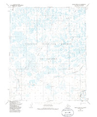
The Meade River winds through the southeastern corner of this North Slope landscape, which was surveyed during the mid-1950s within the boundaries of Naval Petroleum Reserve No. 4. This remote Arctic terrain is defined by a dense network of lakes and shifting waterways, including Pikroka Creek, Agutiroak Creek, and Pisiksagiavik Creek. Human activity in the area is represented by the industrial presence of Meade Test Well No 1 (Drill Hole), a significant marker of early petroleum exploration in the region. Transportation across the tundra was limited to seasonal routes, evidenced by the numerous Tractor Trails and a designated Winter Trail that cross the plain. The map provides a look at the early infrastructure required for resource surveying in the far north before modern development reached the area.
Find a feature on this map
10 named features on this map. Tap any name to fly to it.
Don’t see what you’re looking for? This feature index may not catch every label — zoom into the map to look around manually.
Map Details
Editions of this 1955 Meade River A-3 Map
2 editions found
Other maps of this area

1951 · Meade River
USGS Topo · 1:250,000

1951 · Lookout Ridge
USGS Topo · 1:250,000

1955 · Meade River
USGS Topo · 1:250,000

1955 · Meade River B-3
USGS Topo · 1:63,360

1955 · Meade River A-2
USGS Topo · 1:63,360
1955 · Meade River A-4
USGS Topo · 1:63,360

1955 · Meade River B-2
USGS Topo · 1:63,360

1955 · Meade River B-4
USGS Topo · 1:63,360

1956 · Lookout Ridge
USGS Topo · 1:250,000
1984 · Lookout Ridge D-4
USGS Topo · 1:63,360