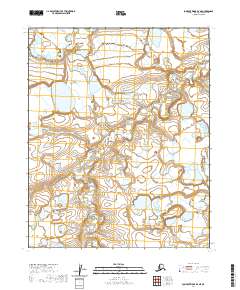
2020 Map of Lookout Ridge D-2 NE
USGS Topo · Published 2020About this map
Usuktuk River dominates this section of the Arctic Slope, meandering across a landscape defined by thousands of years of permafrost and drainage patterns. This 2020 survey provides a high-resolution view of the North Slope's hydrography as recorded by the U.S. Geological Survey and the Alaska Dept. of Transportation. The map captures a vast, roadless expanse where the natural watercourse remains the primary geographical reference point. The detailed contour intervals and public land survey system markers, such as t7n r19w and t7n r20w, reveal the geometric organization imposed upon this wilderness, even in an area where human settlement is entirely absent from the printed record.
Find a feature on this map
6 named features on this map. Tap any name to fly to it.
Don’t see what you’re looking for? This feature index may not catch every label — zoom into the map to look around manually.
Map Details
Editions of this 2020 Lookout Ridge D-2 NE Map
This is the sole edition of this map. No revisions or reprints were ever made.
Other maps of this area

1951 · Meade River
USGS Topo · 1:250,000

1951 · Lookout Ridge
USGS Topo · 1:250,000

1955 · Meade River
USGS Topo · 1:250,000

1955 · Meade River A-2
USGS Topo · 1:63,360
1955 · Meade River A-1
USGS Topo · 1:63,360

1956 · Lookout Ridge
USGS Topo · 1:250,000
1984 · Lookout Ridge D-1
USGS Topo · 1:63,360
1984 · Lookout Ridge D-2
USGS Topo · 1:63,360
2015 · Meade River A-2 SW
USGS Topo · 1:25,000
2015 · Lookout Ridge D-2 SE
USGS Topo · 1:25,000