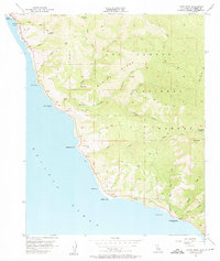
1956 Map of Lopez Point
USGS Topo · Published 1956About this map
Mining Ridge and Coast Ridge dominate this section of the Monterey coast, where the steep Santa Lucia Mountains meet the Pacific Ocean. This mid-1950s survey captures a landscape defined by sharp elevations and narrow canyons, including Big Creek and Limekiln Creek. While most of the interior falls within the Los Padres National Forest, human presence is clustered near the shore at the settlement of Lucia and specialized sites like Slates Hot Springs.
Find a feature on this map
36 named features on this map. Tap any name to fly to it.
Don’t see what you’re looking for? This feature index may not catch every label — zoom into the map to look around manually.
Map Details
Editions of this 1956 Lopez Point Map
4 editions found
Other maps of this area

1919 · Junipero Serra
USGS Topo · 1:62,500

1921 · Cape San Martin
USGS Topo · 1:62,500

1921 · Lucia
USGS Topo · 1:62,500

1941 · Cape San Martin
USGS Topo · 1:62,500

1941 · Lucia
USGS Topo · 1:62,500

1941 · Junipero Serra
USGS Topo · 1:62,500

1942 · Cape San Martin
USGS Topo · 1:62,500

1947 · Lucia
USGS Topo · 1:62,500

1947 · San Luis Obispo
USGS Topo · 1:250,000

1948 · Santa Cruz
USGS Topo · 1:250,000