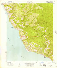
1956 Map of Lopez Point
USGS Topo · Published 1957About this map
The Big Sur coastline south of Monterey presents a landscape of extreme verticality, dominated by the Los Padres National Forest and the precipitous slopes of Mining Ridge. In the mid-1950s, the isolated settlement of Lucia and the nearby Rockland Landing (Aban'd) served as small nodes of human activity along a shoreline punctuated by prominent landmarks like Lopez Point and Gamboa Point. The presence of the Otter Game Refuge and John Little State Park highlights the early emphasis on conservation in this region, where steep canyons like Devils Canyon and deep drainages such as Lime Creek and Vicente Creek limited inland development. This survey documents a period when access to the interior was largely dependent on a network of primitive routes, including the Jeep Trail and numerous foot trails leading to backcountry sites like Lower Bee Camp and Trail Spring Camp.
Find a feature on this map
30 named features on this map. Tap any name to fly to it.
Don’t see what you’re looking for? This feature index may not catch every label — zoom into the map to look around manually.
Map Details
Editions of this 1956 Lopez Point Map
4 editions found
Other maps of this area

1919 · Junipero Serra
USGS Topo · 1:62,500

1921 · Cape San Martin
USGS Topo · 1:62,500

1921 · Lucia
USGS Topo · 1:62,500

1941 · Cape San Martin
USGS Topo · 1:62,500

1941 · Lucia
USGS Topo · 1:62,500

1941 · Junipero Serra
USGS Topo · 1:62,500

1942 · Cape San Martin
USGS Topo · 1:62,500

1947 · Lucia
USGS Topo · 1:62,500

1947 · San Luis Obispo
USGS Topo · 1:250,000

1948 · Santa Cruz
USGS Topo · 1:250,000