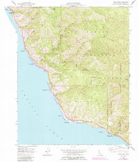
1956 Map of Lopez Point
USGS Topo · Published 1984About this map
Lucia and the surrounding Big Sur coast appear in this survey, showcasing a landscape defined by deep canyons and the precipitous meeting of the Santa Lucia Range with the Pacific Ocean. The map documents early-to-mid 20th-century coastal life before modern expansion, featuring small encampments such as Lower Bee Camp and Trail Spring Camp tucked into the interior highlands. Geologically and ecologically significant markers include the Slates Hot Springs and the protected waters of the California Sea Otter State Game Refuge. Historical industry is hinted at by the presence of Rockland Landing (Aban'd) and Limekiln Creek, where maritime transport once served the region's early resources. The mapping of Devils Canyon and Hare Canyon reflects the complex drainage patterns within the Los Padres National Forest and the Ventana Wilderness Area.
Find a feature on this map
30 named features on this map. Tap any name to fly to it.
Don’t see what you’re looking for? This feature index may not catch every label — zoom into the map to look around manually.
Map Details
Editions of this 1956 Lopez Point Map
4 editions found
Other maps of this area

1919 · Junipero Serra
USGS Topo · 1:62,500

1921 · Cape San Martin
USGS Topo · 1:62,500

1921 · Lucia
USGS Topo · 1:62,500

1941 · Cape San Martin
USGS Topo · 1:62,500

1941 · Lucia
USGS Topo · 1:62,500

1941 · Junipero Serra
USGS Topo · 1:62,500

1942 · Cape San Martin
USGS Topo · 1:62,500

1947 · Lucia
USGS Topo · 1:62,500

1947 · San Luis Obispo
USGS Topo · 1:250,000

1948 · Santa Cruz
USGS Topo · 1:250,000