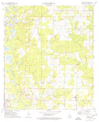
1974 Map of Loranger
USGS Topo · Published 1977About this map
The Tangipahoa River carves through the western edge of this parish landscape, flanked by a complex network of extractive industry and rural community life. Extensive Gravel Pits dominate the riverbanks near Amite, revealing the area's geological utility during the mid-1970s. Further east, the settlement of Loranger serves as a hub for the surrounding countryside, which is densely dotted with family and church cemeteries such as Donaldson Cem, Shiloh Ch Cem, and Briar Patch Cem. The presence of several smaller congregations, including Shady Grove Ch and Hayden Grove Ch, suggests a landscape defined by localized neighborhood centers. Transportation is anchored by the Illinois Central Gulf railroad and a major Pipeline corridor, while Camp Whispering Pines represents the recreational use of the wooded terrain between Big Creek and Little Chappepeela Creek.
Find a feature on this map
60 named features on this map. Tap any name to fly to it.
Don’t see what you’re looking for? This feature index may not catch every label — zoom into the map to look around manually.
Map Details
Editions of this 1974 Loranger Map
This is the sole edition of this map. No revisions or reprints were ever made.
Other maps of this area

1940 · Tickfaw
USGS Topo · 1:31,680

1940 · Roseland
USGS Topo · 1:31,680

1942 · Roseland
USGS Topo · 1:31,680

1942 · Husser
USGS Topo · 1:31,680

1942 · Robert
USGS Topo · 1:31,680

1942 · Wilmer
USGS Topo · 1:31,680

1942 · Loranger
USGS Topo · 1:31,680

1949 · Bolivar
USGS Topo · 1:31,680

1949 · Amite
USGS Topo · 1:31,680

1949 · Albany
USGS Topo · 1:31,680