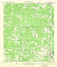
1942 Map of Roseland
USGS Topo · Published 1942About this map
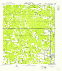
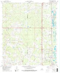
The Illinois Central Railroad serves as the primary spine of development through this portion of Tangipahoa Parish, anchoring a string of timber and agricultural communities. This 1940 field examination reveals a landscape where the dense network of tributaries including Natalbany Creek, Mud Cr, and Jennys Fork flow through a mix of wooded terrain and cleared land. Cultural landmarks are frequent throughout the area, from educational centers like Woodland Sch and Huff Sch to community focal points such as Gaines Chapel and Kedron Ch. Near the southern edge, the settlement of Roseland sits adjacent to Old Gravel Pits, signaling the local extraction industries of the era. The boundary between St Helena Parish and Tangipahoa Parish bisects the western half of the map, illustrating the rural divide between these two North Shore regions.
Find a feature on this map
41 named features on this map. Tap any name to fly to it.
Don’t see what you’re looking for? This feature index may not catch every label — zoom into the map to look around manually.
Map Details
Editions of this 1942 Roseland Map
This is the sole edition of this map. No revisions or reprints were ever made.
Historical Maps of Roseland Through Time
8 maps found