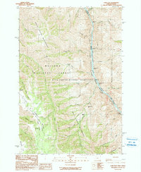
1990 Map of Lord Flat
USGS Topo · Published 1990About this map
The Snake River carves a deep canyon boundary between Oregon and Idaho on this 1990 survey, defining a wilderness where high-elevation flats drop sharply into river-carved drainages. Human presence is sparse and functional, centered around isolated outposts like the Tryon Creek Ranch and Somers Ranch, while the Dorrance Cow Camp sits near the head of Buckaroo Gulch. The landscape is dominated by the Hells Canyon Wilderness, where the lack of developed roads is underscored by the presence of a primitive Landing Strip on the high ground near Lord Creek. Navigating the river corridor requires knowledge of successive whitewater features, including Highrange Rapids, Cottonwood Rapids, and Lookout Creek Rapids. The convergence of the Wallowa National Forest and Nez Perce National Forest highlights the managed but primitive state of this borderland at the close of the 20th century.
Find a feature on this map
49 named features on this map. Tap any name to fly to it.
Don’t see what you’re looking for? This feature index may not catch every label — zoom into the map to look around manually.
Map Details
Editions of this 1990 Lord Flat Map
This is the sole edition of this map. No revisions or reprints were ever made.
Other maps of this area

1954 · Kernan Point
USGS Topo · 1:62,500

1955 · Grangeville
USGS Topo · 1:250,000

1959 · Grangeville
USGS Topo · 1:250,000

1963 · Cactus Mtn
USGS Topo · 1:24,000

1963 · Kirkwood Creek
USGS Topo · 1:24,000

1963 · Joseph
USGS Topo · 1:24,000

1963 · Grave Point
USGS Topo · 1:24,000

1963 · Wolf Creek
USGS Topo · 1:24,000

1980 · Grangeville
USGS Topo · 1:100,000
1990 · Sleepy Ridge
USGS Topo · 1:24,000