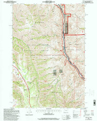
1995 Map of Lord Flat
USGS Topo · Published 1999About this map
Snake River serves as the powerful physical and political boundary between Oregon and Idaho on this 1995 survey. The map documents a landscape defined by the sheer verticality of Hells Canyon, where the river is punctuated by navigational hazards like Highrange Rapids and Lookout Creek Rapids. While much of the area is protected within the Hells Canyon Wilderness and Wallowa-Whitman National Forest, evidence of human activity remains in the scattered outposts and cattle operations. Researchers can find Somers Ranch Corral, Tryon Creek Ranch, and the Dorrance Cow Camp situated near seasonal water sources. The presence of a Mine Tunnel and various Prospects near Getta Creek point to a history of resource exploration along the canyon's rim, while the Western Rim National Recreation Trail traces the high ground of Summit Ridge.
Find a feature on this map
50 named features on this map. Tap any name to fly to it.
Don’t see what you’re looking for? This feature index may not catch every label — zoom into the map to look around manually.
Map Details
Editions of this 1995 Lord Flat Map
This is the sole edition of this map. No revisions or reprints were ever made.
Other maps of this area

1954 · Kernan Point
USGS Topo · 1:62,500

1955 · Grangeville
USGS Topo · 1:250,000

1959 · Grangeville
USGS Topo · 1:250,000

1963 · Cactus Mtn
USGS Topo · 1:24,000

1963 · Kirkwood Creek
USGS Topo · 1:24,000

1963 · Joseph
USGS Topo · 1:24,000

1963 · Grave Point
USGS Topo · 1:24,000

1963 · Wolf Creek
USGS Topo · 1:24,000

1980 · Grangeville
USGS Topo · 1:100,000
1990 · Sleepy Ridge
USGS Topo · 1:24,000